
As I was thinking about how rainy and cold this winter has been for Southern California (and almost every other corner of California, especially Central California), I recalled that the National Weather Service issues “climate outlooks” at the start of every season, and I wondered what they had predicted for this one. I had read it; I read them all. But I couldn’t remember what the prediction had been.
Weather is the main source of drama in my life. I don’t watch TV, and I can’t remember the last movie I saw.
But I aim to grow nearly all of the fruits and vegetables my family eats. Because of this, I read the weather forecast at least once each day, as upcoming rain or wind or heat or frost or hail has a great effect on my daily activities. And a dangerous forecast makes me feel suspense, worry, drama.
So I looked back for that “climate outlook” before this winter. I found that on October 10, 2022, the National Weather Service issued the following prediction for the winter of 2022-2023, specifically December through February. For temperatures, the prediction was that they would be above average, a warmer-than-normal winter. For rainfall, the prediction was below average, a drier-than-normal season.
Again on December 15, 2022, the National Weather Service came out with a new “Climate Update, Winter 2022-2023 Outlook,” specifically for January through March. But the prediction was the same: the winter would be drier than average and warmer than average.
One graph in this climate prediction showed a “very low” 20-40% chance that California would reach average rainfall for the year. This prediction shared by the National Weather Service came from the Center for Western Weather and Water Extremes at Scripps, UC San Diego.
These climate forecasts were the opposite of correct. In fact, it seemed as if the sky heard the December prediction and immediately set to making it look foolish. Clouds soon rolled in, temperatures soon dropped, and within two weeks it was raining and it has barely let up since.
A month after that December 15 forecast, an updated NWS video reported that between December 21 and January 19 almost all of California received “two to four times as much [precipitation] compared to normal.” It ranked as the wettest period on record for those dates for some California locations. (I wrote about this period in my post, “That string of storms.”)
For my location in San Diego County, as of today, 28.85 inches of rain has fallen so far this water year, which starts on October 1. This already nearly doubles the average (of about 15 inches) in an entire water year, which doesn’t end until September 30. Up near Santa Barbara has received way more.
You lived through it. You know how wet it has been. You’ve seen the flooding and the extreme snowfall in our mountains. How often have you irrigated your garden this winter?
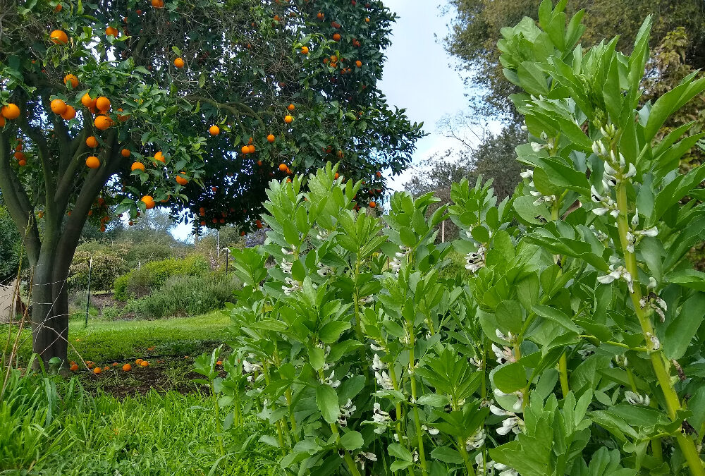
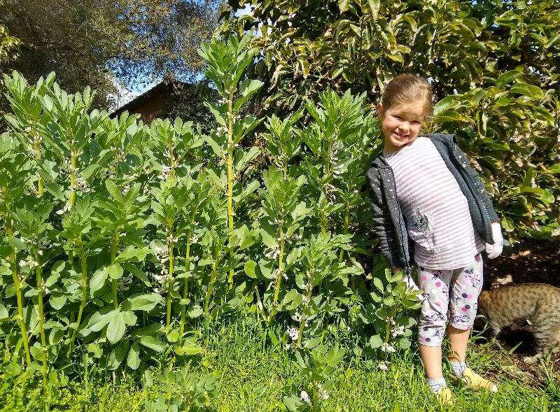
I haven’t irrigated anything for three months. On November 13, my daughter sowed a patch of fava beans. She never returned to water them and this is how they’ve thrived on rainfall alone.
Then there is the snail’s pace of growth of plants that need warmth. As of today, there is still not a single avocado flower open on any of my trees. Last year, I had first flowers open on January 16. In 2021, I had first flowers open on January 19. It looks like I’ll have first flowers opening on my avocado trees this year in a week or two, so that’s the end of March or beginning of April — retarded by more than two months by this abnormally cold winter.
I am humbled by the complexity of nature, weather, and climate such that meteorologists and climate scientists continue to have zero demonstrated ability to predict what the atmospheric conditions will be like more than a week or two into the future.
I use this past winter as an example here, but the pattern has been the same over the many years I’ve been paying attention to the National Weather Service forecasts and those of private meteorologists. Beyond a couple weeks, I’ve never seen anyone forecast with more accuracy than a flip of the coin. (Please let me know of anyone with a significantly better track record.)
Simultaneously, I am amazed by the ability of forecasters to predict the weather in the very near future. For example, on Tuesday morning of this week (March 21), the meteorologists of the National Weather Service in San Diego predicted 2.5 to 3 inches of rain would fall on my area that day through Wednesday night. Here is what my rain gauge looked like on Thursday morning.
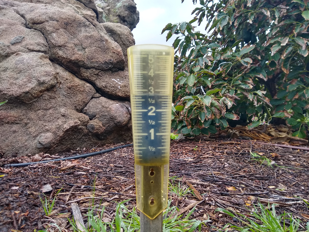
Right on the money!
What to do with all of this in your garden? Use the weather forecasts for the next few days to prepare to protect plants from dangerous cold or dangerous heat, or to prepare to irrigate or harvest rain.
But rely on historical averages for your window into the more distant future, recognizing that every year departs slightly from the average in one way or another.
Pay no mind to forecasts of what the weather or climate will be like a couple weeks out, let alone a couple months or years out. The evidence shows that meteorologists and climate scientists, and the computer models they build to produce forecasts, are of no use in guiding us that far into the future.
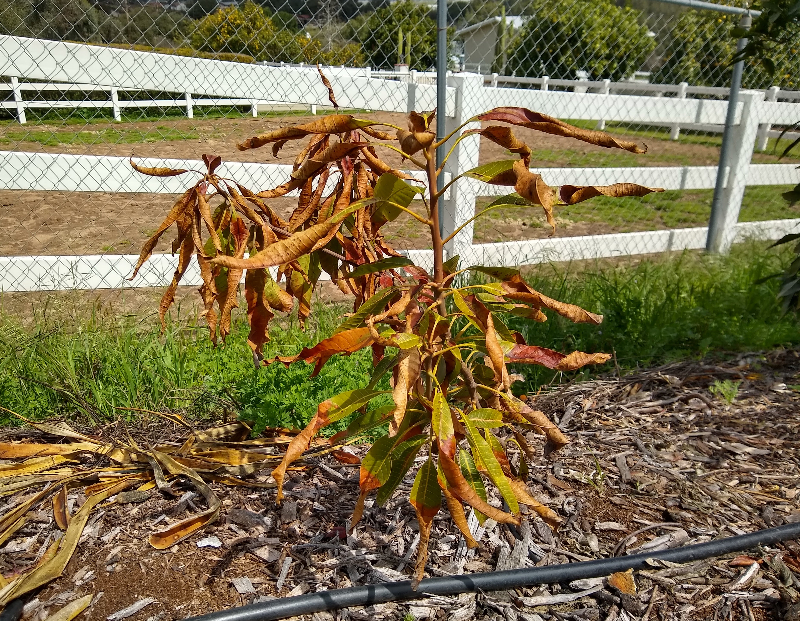
If such prognostications could be reliably made, then I would have been told that this winter was going to be colder than normal and I would have waited until here in spring to plant this baby mango.
All of my Yard Posts are listed HERE
I hope you find my Yard Posts helpful, and I appreciate your support so I can continue. Thank you.


Great Post, I haven’ watered since November either, absolutely fantastic. I did lose a 2 year ross sapote and a 3 year old papaya (Pretty sure they drowned). Today I’m seeing the bees get to work and hopefully we get the perfect “storm” of good weather for pollinating. On a hillside in Whittier!
San Diego Resource Conservatory came to my property to get soil samples, they had funding through end of market for free analysis.
http://www.rcdsandiego.org/
We were talking about mulch, and they mentioned that 1% more organic matter per acre could hold 10,000 gallons more water. I thought, we have gotten 25 inches of rain, how many gallons of water is that for an acre. Well, turn out over half a million gallons. That is a lot of water, i think our mulch kept a lot on the property.
Great post, as usual! This winter has been crazy. I don’t know if you follow Dr. Daniel Swain, who is a climate scientist at UCLA, but he has a great blog, twitter account, and youtube channel. Don Shor from the Davis Garden Show turned me onto him. He dives into a lot of the complexities you talk about here, especially in his most recent youtube office hours. Search for “weather west” and/or his name, and he’ll pop up.
Hi Holly,
Thank you very much. This winter has been crazy. There is water seeping out of the ground all over my neighborhood these days!
I used to read the Weather West blog but haven’t visited in a while. Daniel Swain has some interesting notes on current weather but his predictions of anything beyond a week or two I’ve found to be just as inaccurate as those of others.
For example, on November 21, 2022, he wrote: “La Niña’s still chugging along in the eastern tropical Pacific Ocean, and the tropical West Pacific’s still really warm. That’s a pattern that, as discussed in many previous posts, favors the persistence of Northeastern Pacific ridging during winter–and this winter will likely be no exception. The exact placement of that ridge axis dictates whether California ends up warm and dry near the central ridge axis, or cool and relatively wet just far enough east of the ridge axis to see frequent cold storms diving southward from the Gulf of Alaska and western Canada. Right now, the seasonal models continue to suggest that the ridge is likely to set up in a position that keeps most or all of California–along with much of the Lower Colorado River basin–drier than average during the Dec-Mar peak of the rainy season, and into the spring thereafter.”
See: https://weatherwest.com/archives/20787
It’s dressed up in technical language, but we shouldn’t be distracted. It’s as inaccurate as inaccurate can be. “. . . most or all of California . . . drier than average during Dec-Mar.”
I don’t want to sound harsh, but I believe that we have to judge folks by their fruits. I want to be judged by my fruits. If I claim that a Bing cherry is likely to produce well in your yard, and you plant one and it never bears, you should hesitate to listen to my advice about cherry trees going forward.
Thanks, Greg, I appreciate your reply. What I specifically thought you’d enjoy about his latest youtube video was that he talked about how wrong he (and others) have been, especially with regard to this year, and the more technical reasons behind why seasonal and other longer-range forecasts are not very accurate. It was interesting. As a scientist myself, I really like discussions on the limitations of these sorts of models.
Thanks so much for pointing me to that, Holly. Sounds very interesting. I’ll check it out.
Poor mango!
Hi Greg,
I planted two mangoes last autumn but now they look the same as yours! It was frosty here, some avos look the same…😥
Can we expect them to come back and recover?
BTW, I planted a Irvine and a Keith.
We live in Sonoma and we’re about 1/2 hour from Santa Rosa which has received 40 inches of rain since October 1st. It feels like we’ve been living deluge to deluge! My favas are popping with blooms like your daughter’s – but no pods yet? They are in raised beds and I read that if they are in wet soil (lots of rain) they will produce blooms not pods. Any ideas? Or maybe it’s also been too cold?
Hi Mariangela,
I’ll have to pay attention to that. I’ve never heard of that happening. I have seen the plants bent over on many frosty mornings, but they’ve mostly recovered well. I’ll report on how the pod production turns out.
We’ve got tons of blooms and even with the last 2 months of frosts they have kept flourishing (I have them in 6 raised beds). We’ve been eating the leaves and some blossoms in salads and cooked like spinach. So great!
I’ve never eaten fava leaves and blossoms. Can’t wait to try them now.
I measured 2.75″ in my backyard during this last week (March 23) in Murrieta. I had lots of puddles and one hole I had dug for a new plum is full, 32″ deep and wide.
Enjoy being posted.
I may not like how inaccurate the long range predictions are, but I’m impressed how accurate they are becoming for the near future. The computer age is able to put in a lot of data and continually make changes as more annual data are added.
I write books and articles on theology. The Bible tells us that in the Last Days, there will be more weather extremes, (floods, droughts, hurricanes, tornadoes, etc;) Earthquakes, too. And of course, evil becoming more rampant. These occurrences are likened to birthpangs, becoming progressively harder and more frequent.
Very interesting, David. Can you share some chapters and verses to look at?
When we removed our lawn last May/June to plant a native scape with drip lines, we were advised by the turf replacement program to take our time with the new plantings because the drought conditions were expected to last for at least 2 more years, according to their models. We didn’t delay the planting, and finished well ahead of the year deadline they gave us (rebate program). Now the new native pollinator plants are attracting lots of bees & butterflies! The flowers on the avocado trees have started to open up this past week, even with this cool weather. But at least the sun is coming out! 1/2 block from the coast in LA.
I bet your natives look awesome. And they’ll probably get even better over the next month or so.
I’ve been trying to get many hikes in because the native vegetation in the hills and canyons are also beginning to bloom wonderfully this year.
Hi, Greg, There are bits and pieces throughout the whole Bible that speak of the days we are in. I think these 2 places in the New Testament will give some idea of what signs to look for: Matthew 24:4thru 8, and Luke 21: 7thru 36. But the biggest sign happened in 1948 when Israel became a nation in one day! We are told the generation that sees that will not pass away before the end of this age comes. Matthew 24:34.
Based on the following data, anyone who thinks he/she can out-predict a coin flip would be foolish: since 1850 (through 2021) mean rainfall in San Diego: 9.84 inches (it’s over 10″ now since the weather service averages on the last 30 years only). Here’s the kicker: the standard deviation during that same stretch is 4.18 inches. The variability year by year is pretty tremendous. Interestingly, over the past 170 years the rate of rainfall in San Diego has increased slightly.
I think we’ve had over a foot of rain since December near SDSU. I have a customer we did drainage work for at the end of last year and the big driver in her having us do the job was that we’re both natives of San Diego and remember that when it wants to rain here it can really rain, despite what the forecasters say. We’re both very happy she did this work and didn’t end up with two swimming pools otherwise.
Back when I planted all sorts of trees I told my wife I was panting a few very high chill varieties because every now and then we have a pretty cold winter, and even though this wasn’t the coldest we’ve seen it sure had been a prolonged cold, which is great for chill hours. I can’t say for sure why some of these non bloomers are blooming this year but is has to be either the cold or wet or both.
Maybe we’re in for a few years of cold, who knows? I did hear some interesting stories, though, of the sun being pulled it’s own width away from us because Jupiter and Saturn are opposite us right now. This combined with the northern hemisphere’s winter has mixed things up a little. It’s an interesting theory to say the least.
A good site for weather and waves.
https://wavecast.com/socal/